Maps
The Middle East in general and the Gulf region, including the United Arab Emirates, are among the areas facing serious challenges concerning water scarcity. For example, the average calculated water scarcity index for 2018 in arid areas is 12.4, which means that the rate of freshwater exploitation is more than 12 times its renewability rate. This situation has created many problems, such as groundwater depletion, aquifers dewatering, and salt-water intrusion into coastal aquifers. Over the last few decades, water demand has increased rapidly due to population growth, remarkable expansion in the urban areas, economic development, and changes in lifestyle, which effectively have led to the increase in water demands for irrigation, domestic uses, touristic activities, and industrial processes. In addition, due to climate change variability, sustainable long-term supply of fresh water is becoming more challenging than ever before. Irrigation is the largest water consumer in the UAE with three main sectors: agriculture, forests, parks and landscaping, whose needs are met by groundwater, treated wastewater, and desalinated water. Freshwater scarcity has driven the country to desalinate large volumes of seawater to meet the domestic water demand.
The UAE government is constantly working to improve water resource management and conservation standards, to devote attention to ways to conserve, develop and develop non-conventional water sources. Apply and adapt to the integrated water resources management system to coordinate the demand for freshwater and conserve its limited and available resources as well as develop strategies for water conservation within the main objective of sustainable development through water conservation and integrated management for the benefit of current and future generations.
The following geopotential maps are produced to give a general view of water availability and the main hydrogeological parameters of the country s aquifers.
Rainfall
Average Annual Rainfall
The lowest rainfall is observed in the desert foreland and the highest in the mountains and east coast of the region. The estimated mean annual rainfall of east coast is about 94 %, gravel plain is 82% and desert foreland is 57% of annual mean rainfall of mountain area .

Annual average precipitation in mm of UAE
Climatological Stations
Used to measure rainfall and estimate average precipitations and runoff processes in all areas. Understanding the regional and temporal variations in precipitations is vital for water resources planning and hydrologic studies. The rainfall patterns may significantly affect the agriculture productivity as the cycles of maximum or minimum precipitation may coincide with peak growing season.

Climatological stations of UAE
Hydro-Geological Settings
Geology
The geological structure, stratigraphy, and lithological settings define the physical characteristics of the groundwater aquifers and determine the extent and patterns of groundwater flows. The mineral composition of bedrocks and the unconsolidated surficial deposits largely governs the chemical quality of groundwater. The lithology of the aquifers can be divided into consolidated and unconsolidated lithological units classified into fluviatile or alluvium, eolian, and sabkha deposits.

Geological map of UAE (modified from EAD, 2010)
Topography
Digital Elevation Model (DEM) at 90 meters resolution processed to create a thematic map of ground surface elevation grids required to determine the drainage networks, drainage basins, slope values and directions, and flow accumulation in the ponding zones.

XYZ grid thematic map of topographic elevation derived from a DEM model by USGS for UAE
Saturated thickness of surficial aquifer
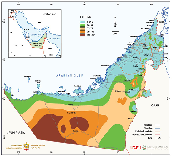
The map indicates that the average thickness of the saturated zone of the surficial aquifer in the UAE ranges from less than 20 meters in the mountainous areas of the northern Emirates to 50 meters in the rest of the regions except in Liwa, where the saturated thickness reaches more than 100 meters.
Soil Type
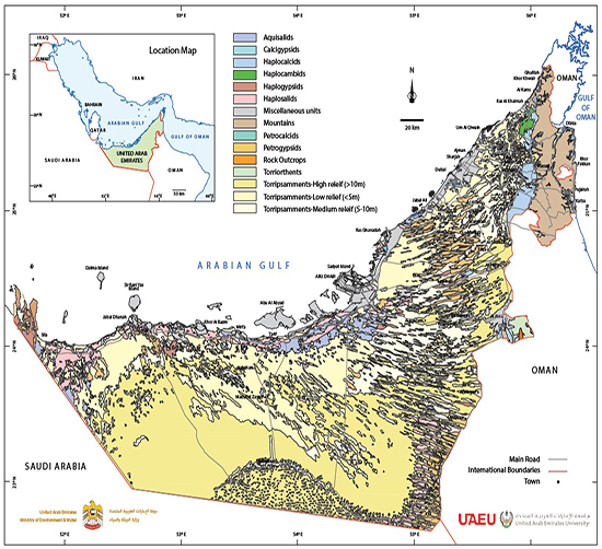
The soil map provides an overview of soil types making up the United Arab Emirates and their general location. The map unit descriptions provide information about the general range of important soil properties of the soil great group.
Water Table Depth
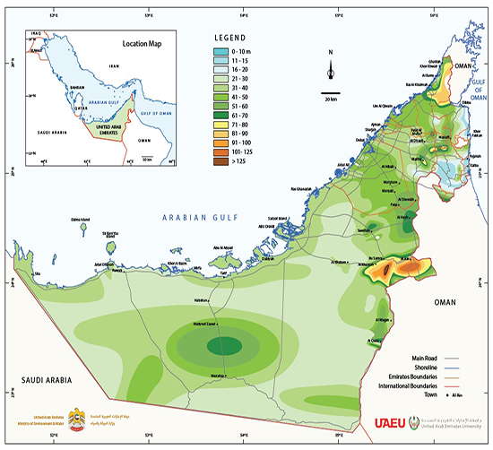
Water tables depths below ground surface recorded from monitoring wells. Increase in depths observed in Al Ain, Al Dhayd, and Al Hamaranyah is caused by over-abstraction thus depleting the saturated thickness.
Land use
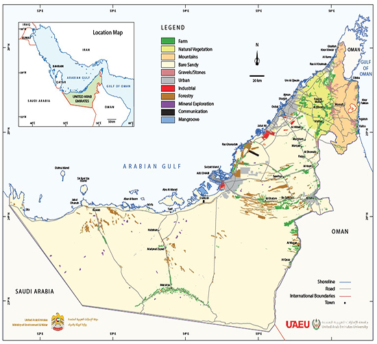
Different uses of land including agricultural areas, urban areas, and forests are derived from recent Landsat images at spatial resolution of 30 meters.
Spatial and temporal changes in groundwater levels and salinity
The levels and quality of groundwater are periodically monitored in all regions of the country and these measured data from observation wells are used to identify areas of low water level and groundwater salinity. For example, during the period 1969-2009, a significant change in groundwater levels and salinities was observed. The decline in the groundwater table in the middle of the distance between Dhayed and Hamrania during that period exceeded 100 meters. The decrease in the groundwater level was accompanied by an average increase in salinity of 15 g/l. This change in the groundwater levels disturbs the pattern of regional groundwater flow and significantly increases the groundwater salinity, whether because of horizontal seawater intrusion or vertical upward of deep saline groundwater.
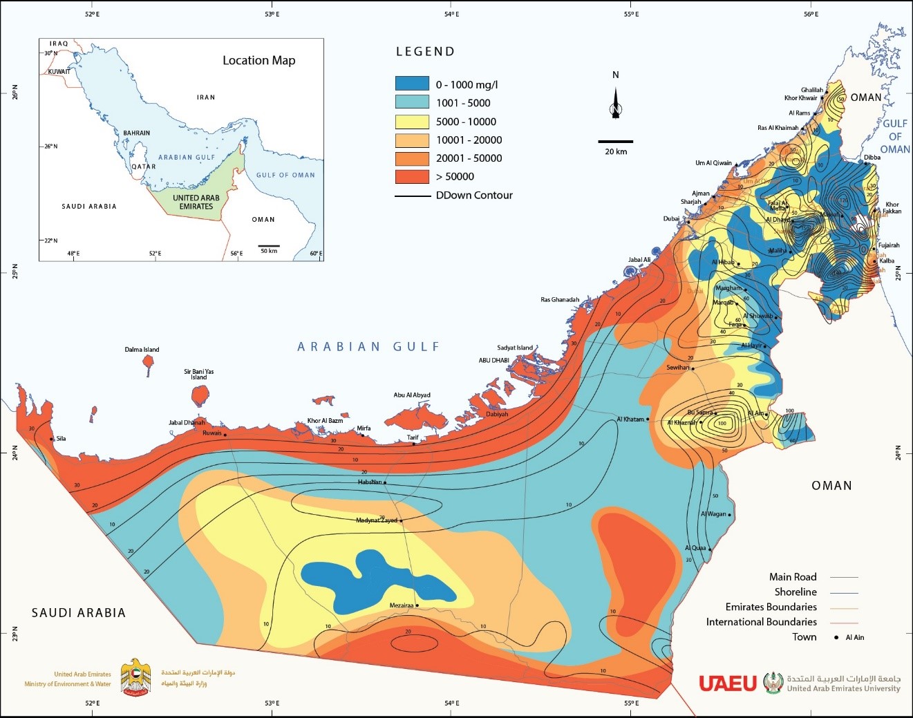
Salinity increases of the Surficial /Quaternary aquifer in 1969-2009 with contours of decline in water table elevation
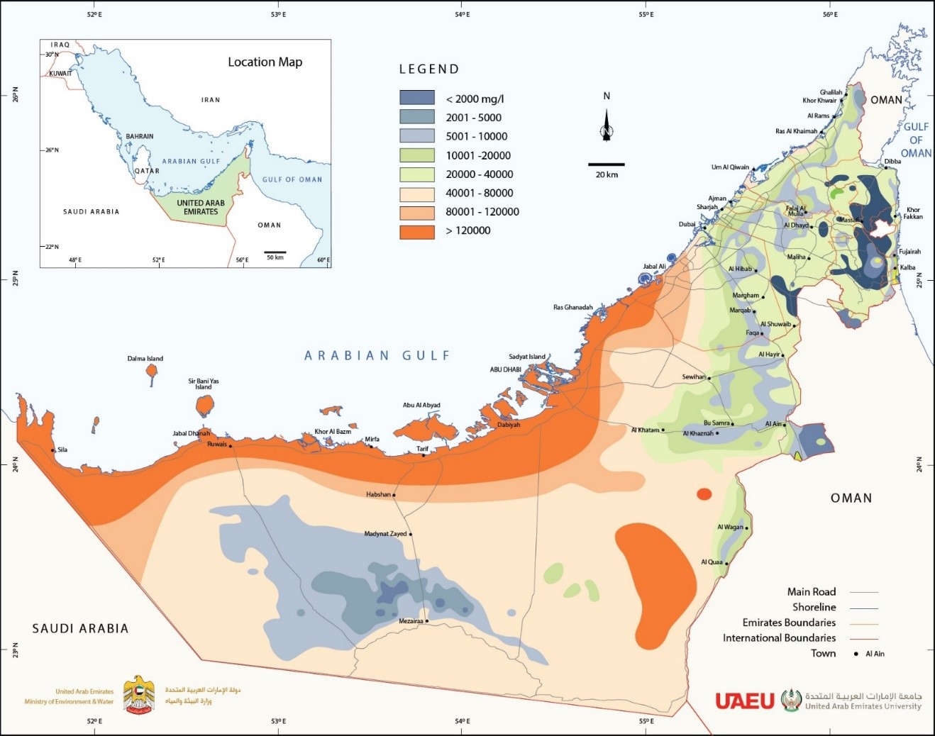
Groundwater salinity in the Surficial /Quaternary aquifer in 2012
Do you find this content helpful?
عفوا
لايوجد محتوى عربي لهذه الصفحة
عفوا
يوجد مشكلة في الصفحة التي تحاول الوصول إليها

